 |
 |
Misfits |
 |
 |
Misfits Trips |
2004 |
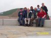
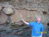
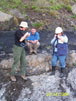
On Saturday we walked along the beach from Telpyn Point towards Amroth. Lynfa had supplied us all with copies of geological notes reproduced by kind permission of the original author, Sid Howells.
Extract from notes:
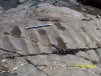
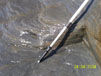
The rocks exposed in this area referred to as Coal Measures, and they consist mainly of sandstones, siltstones and shales. There are also some thin (generally less than 0.5m) coal seams (locally referred to as 'veins') and in some areas the shales yield ironstone nodules.
The Pembrokeshire Coal Measures were deposited in part of an elongated belt of deltas that bordered the northern margin of a rising mountain chain created by the collision of two continents (Gondwana and Laurasia). The entire area lay close to the equator and was subject to a warm tropical, possibly monsoonal, climate. Rivers flowed across the delta plains in a complex system of distributary channels bordered by raised banks (levees) covered by tall 'trees' (related to smaller modern forms such as ferns, horsetails and clubmosses). The areas between the channels were also covered by luxuriant swamp vegetation which generated considerable quantities of plant debris that accumulated to form peat. When flooding periodically broke through the levees it killed the vegetation which fell down into the water and was covered by sediment until the water became shallow enough again for plants to grow. As these layers built up the peat initially formed from the vegetation was compressed to form coal. The peat layers ... probably accumulated over thousands of years whereas the same thickness of sediment (sand, silt or mud) could have accumulated in a few years or less. The closest modern analogue ... appears to be the Atchafalaya Swamp on the western margin of the Mississipi Delta. ...
The Coal Measures were formed between 320-290 million years ago, during the latter part of the period of geological time known as the Carboniferous. ...
On Sunday we visited the Big Pit: National Coal Museum at Torfaen, South Wales.
Big Pit was originally an iron ore mine; it was only after the miners had burnt all the trees in the area for the smelting purpose that they discovered the shiny black rock under the iron seams also could burn. In the end the coal mining out-lived the iron ore mining and only ceased in the 1980s.
|
 |
|
|
|
|
|
|
|
|
|
|
|
|
|
 |
 |
 |
 |
 |
 |